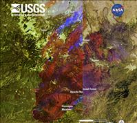
The Landsat 5 satellite had captured images at different times of the Wallow and HorseShoe 2 wildfires to help firefighters plan strategies for managing what is being called Arizona’s most devastating wildfires in the state’s history.
The flooding of the Mississippi has also been a problem with levees giving way and flooding land near the river.
Besides mapping terrain, the Landsat 5 satellite is able to calculate temperature differences and smoke from the fire. Examples of interactive imagery with before and after satellite photos of the disasters are being shown of the Arizona wildfires and the Mississippi flooding. It can viewed at http://eros.usgs.gov/#/About_Us/Views_of_the_News
By: Victoria Brown
