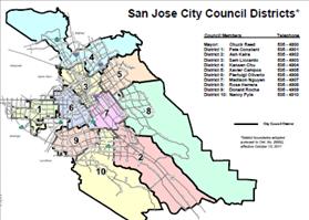
 Digital News Report – The city of San Jose has compiled their new district map (see below). The district maps are a culmination of a year-long redistricting process.
Since 1978 there have been ten districts, with one mayor elected at-large from all of the districts. Before 1978, there were only seven districts which included a rotating mayor.
Every ten years cities are required to redraw their districts using census data. There are several criteria that need to be considering when drawing the district lines, including ethnicity and population.
In August the city council approved the new district boundaries. All of the council members voted for the plan, with the exception of first district supervisor Pete Constant.
“The new District 1 boundaries will extend from Winchester Boulevard to Highway 17,” Constant said in a statement. “However, Santana Row will still remain in District 6”.
By: Mark Williams
Local Reporter
