| Listen to our audio presentation: History of the US Supreme Court |
Hurricane Helene, a rapidly intensifying and unusually large storm, is set to make landfall in Florida’s Big Bend tonight as a catastrophic Category 4 hurricane. With maximum sustained winds now reaching 120 mph, according to the Air Force Hurricane Hunters, the storm’s destructive force has already led to widespread warnings. The National Hurricane Center is sounding the alarm about the “life-threatening” storm surge, expected to reach up to 20 feet along parts of the Gulf Coast.
- Hurricane Helene is expected to make landfall tonight in Florida’s Big Bend as a dangerous Category 4 storm, with sustained winds of 120 mph.
- Life-threatening storm surges of 15-20 feet are forecast along Florida’s Gulf Coast, potentially causing catastrophic flooding in coastal areas.
- The storm’s massive wind field, extending 275 miles from its center, will bring damaging winds and heavy rain far inland, affecting areas up to the Appalachian Mountains.
- Residents are urged to complete preparations, follow evacuation orders, and brace for widespread power outages, flash floods, and possible tornadoes across the Southeast.
The National Oceanic and Atmospheric Administration (NOAA) reported that Helene’s massive wind field extends 275 miles from its center, meaning its effects will be felt long before landfall and as far inland as the Appalachian Mountains. Residents along the Florida coastline and further inland have been urged to rush preparations to completion.
Yahoo News reported that Helene is expected to arrive as a powerful Category 4 storm tonight, with potential to cause devastating flooding, wind damage, and power outages. The size and intensity of the storm are particularly concerning, with storm surges threatening coastal communities from Carrabelle to Suwannee River, Florida. Parts of the coastline could face up to 20 feet of water pushed inland by Helene’s destructive winds and tides.
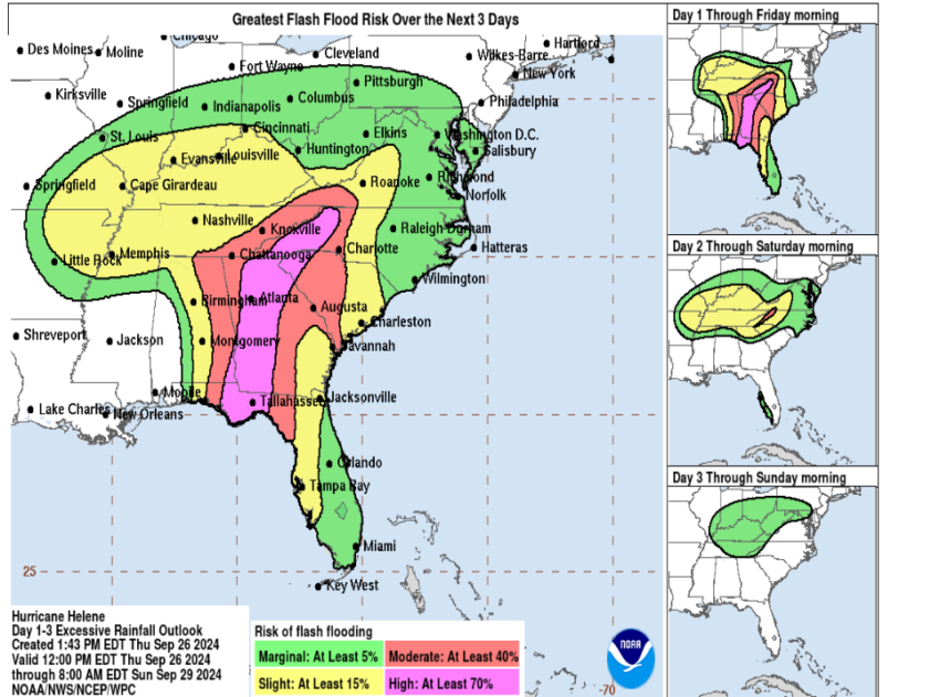
Warnings have also been issued for much of Florida, with hurricane-force winds likely to batter regions far beyond the coast. The storm is expected to penetrate inland across northern Florida, Georgia, and into the southern Appalachians, with damaging winds persisting into these regions due to the storm’s speed and size. Flash flooding is also a major concern, as the storm could bring 6 to 12 inches of rain across the southeastern U.S., with isolated areas seeing as much as 20 inches of rainfall.
Tallahassee Democrat reported that Florida State University (FSU) has been taking precautions in preparation for Helene’s arrival. Safety measures at the athletics facilities have been reinforced, as the Seminoles football team evacuated a day early to ensure their safety ahead of their scheduled game.
With the storm intensifying quickly, emergency services across Florida are urging residents to heed all warnings and evacuate if advised. The NOAA has emphasized the potential for catastrophic damage, with tornado risks gradually increasing across northern Florida, southeast Georgia, and the Carolinas as the storm progresses.
Helene’s impact will not only be felt at landfall but will extend well inland as heavy rains and strong winds are expected to trigger landslides in the southern Appalachians. The region is preparing for significant river flooding and dangerous travel conditions.
As the Florida Gulf Coast braces for what could be one of the most destructive hurricanes in recent history, residents are being urged to stay safe, follow evacuation orders, and prepare for prolonged power outages.

