| Listen to our audio presentation: History of the US Supreme Court |
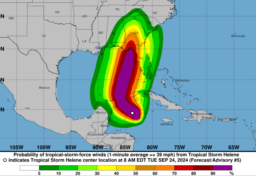
Tropical Storm Helene, which formed on September 24, 2024, in the western Caribbean, is expected to rapidly intensify into a major hurricane as it approaches the Florida Gulf Coast by Thursday. Currently, Helene is producing sustained winds of 45 mph and is steadily organizing over warm waters near the Yucatan Peninsula. The National Weather Service has issued hurricane and storm surge warnings for parts of Florida, with the threat of life-threatening conditions increasing as the storm develops.
- Tropical Storm Helene is expected to intensify into a major hurricane as it approaches the Florida Gulf Coast by Thursday night.
- Storm surge warnings are in effect, with predictions of 5-8 feet of water in Tampa Bay, potentially the highest levels on record.
- Heavy rains will impact western Cuba, Florida, and much of the Southeast, leading to flash flooding and urban flooding.
- Hurricane and storm surge watches have been issued for the Florida Panhandle and the west coast, with damaging winds likely.
- Residents in affected areas should follow local evacuation orders and monitor updates for their safety.
According to the latest advisory from NOAA, Helene is forecast to strengthen to near-hurricane status by Wednesday as it moves through the northwestern Caribbean Sea, impacting western Cuba and the Yucatan Peninsula with tropical storm-force winds. The Weather Channel noted that the storm is expected to rapidly intensify into a “large, major hurricane” as it enters the Gulf of Mexico, bringing significant risks of storm surge and flooding along the Florida Gulf Coast by Thursday evening.
Yale Climate Connections reported that Helene’s storm surge could reach historic levels, particularly in Tampa Bay, where water levels are predicted to rise between 5 to 8 feet, the highest since record-keeping began in 1947. The risk extends beyond coastal areas, with the potential for widespread flooding throughout Florida, the Southeast, and the Southern Appalachians. Flash flooding is expected to be a major concern across both urban and rural areas as heavy rains move inland.
Helene’s intensification is being driven by favorable conditions in the Gulf, though upper-level wind shear has so far limited the storm’s thunderstorms to the east of its center. This shear is expected to weaken, allowing the storm to consolidate and grow in strength as it approaches land. Forecasters are closely monitoring its track, with the National Hurricane Center projecting a likely landfall near Florida’s Big Bend region on Thursday night. The storm will then bring heavy rains and strong winds far inland into the Tennessee Valley by Friday.
Residents in hurricane-affected zones are urged to follow evacuation orders and take precautions as the storm approaches. NPR emphasized the importance of local advisories, especially for those in low-lying and flood-prone areas. With storm surge and heavy rainfall expected to be the primary threats, it’s crucial for individuals in the path of the storm to stay informed and prepare for possible impacts.

