| Listen to our audio presentation: Ancient Bond Between Dogs and Humans |
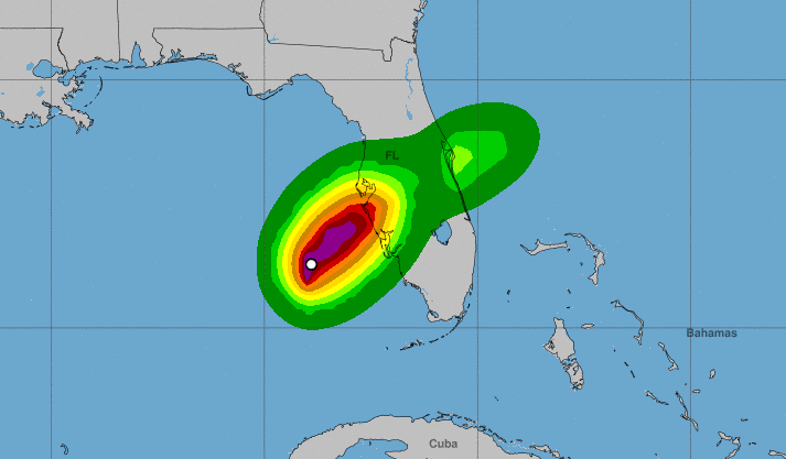
Hurricane Milton, a powerful and life-threatening Category 3 storm, made landfall near Siesta Key, Florida, on the evening of October 9, 2024. The National Hurricane Center confirmed the storm’s arrival, noting sustained winds of up to 120 mph. NOAA reported wind gusts as high as 100 mph in several areas, with severe storm surge and flash flooding affecting the west-central coast of Florida.
- Hurricane Milton made landfall near Siesta Key, Florida, as a Category 3 storm, bringing winds up to 120 mph and gusts of 100 mph.
- A life-threatening storm surge of up to 10 feet is flooding coastal areas, with rapid water level rise expected as the storm moves inland.
- Residents in central and southern Florida are facing hurricane-force winds and the risk of tornadoes through the evening.
- Heavy rainfall is causing flash flooding, with major river flooding possible across the Florida Peninsula through Thursday.
- Evacuation orders are in effect, and residents are urged to seek shelter in interior rooms and stay informed as the storm progresses.
According to USA Today, Milton had briefly strengthened to a Category 5 hurricane while in the Gulf of Mexico, with wind speeds reaching 160 mph. Although it slightly weakened before landfall, it remains a formidable force, with extreme weather conditions sweeping across the state. Florida Governor Ron DeSantis urged residents to “prepare for the worst” as the storm approached, warning of major impacts on the state’s west coast.
The storm surge, predicted to reach heights of 10 feet or more in some areas, has already caused significant coastal flooding. The Weather Channel emphasized the life-threatening nature of these surges, particularly along Florida’s Gulf Coast, where water levels are rising rapidly. As the storm’s eye moves inland, onshore winds are driving additional flooding along both the Gulf and Atlantic coasts.
In addition to the dangerous storm surge, the National Weather Service has issued warnings about hurricane-force winds spreading across the peninsula, including parts of the Florida east coast. NPR reported that gusts are expected to persist into the night, with the risk of strong tornadoes continuing across the southern and central regions of the state. Residents are advised to seek shelter in interior rooms away from windows to stay safe from flying debris.
The storm is also bringing heavy rainfall, increasing the risk of both flash flooding and river flooding throughout the Florida Peninsula. Rainfall totals could trigger moderate to major flooding, particularly in low-lying areas, as reported by the National Hurricane Center. Authorities are closely monitoring conditions as Hurricane Milton moves northeast across the state, with its eye expected to exit the Florida coast near Daytona Beach by Thursday morning.
As residents across Florida face this historic storm, emergency services are on high alert, and evacuation orders remain in effect in vulnerable areas. The storm’s path and strength continue to be monitored, with updates provided by NOAA and local officials. Those in the storm’s path are encouraged to stay informed, follow official warnings, and take shelter as necessary to protect themselves from the worst effects of this powerful hurricane.

